
airport information
location
FAA Identifier: PWA
Lat/Long: 35-32-02.999N / 097-38-49.391W
35-32.04998N / 097-38.82318W / 35.5341664 /
-97.6470531 (estimated)
Elevation: 1299 ft. / 395.9 m (surveyed)
Variation: 07E (1985)
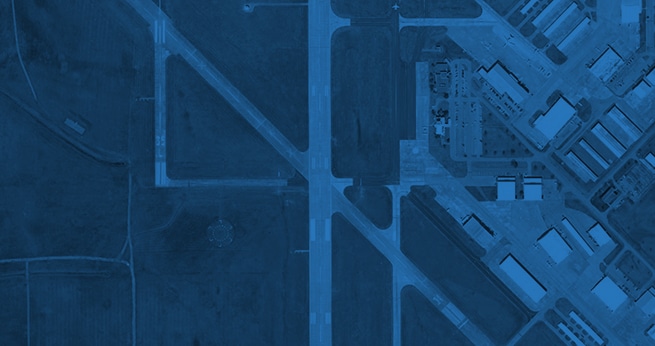
From city: 7 miles NW of OKLAHOMA CITY, OK
airport communications
CTAF: 126.9
UNICOM: 122.95
ATIS: 128.725(405-495-4063)
WILEY POST GROUND: 121.7 [0700-2200]
WILEY POST TOWER: 126.9 306.9 [0700-2200]
OKE CITY APPROACH: 120.45(081-170) 124.2(001-080)
120.45(081-170) 124.2(001-080)
OKE CITY DEPARTURE:120.45(081-170) 124.2(001-080)
120.45(081-170) 124.2(001-080)
EMERG: 121.5 243.0
IC:124.6(171-360)
WX ASOS at OKC (9 nm S):PHONE 405-682-4871 WX AWOS-3 at OUN (19 nm SE): 119.55 (405-325-7302)
airport operations
Airport use: Open to the public
Sectional chart: DALLAS-FT WORTH
Control tower: yes
ARTCC: FORT WORTH CENTER
FSS: MC ALESTER FLIGHT SERVICE STATION [1-800-WX-BRIEF]
NOTAMs facility: PWA (NOTAM-D service available)
Attendance: CONTINUOUS
Wind indicator: lighted
Segmented circle: yes
Lights:DUSK-DAWN
WHEN ATCT CLSD ACTVT HIRL RY
17L/35R & MALSR RY 17L - CTAF.
Beacon:white-green (lighted land airport)
nearby radio navigation aids
| VOR radial/distance | VOR name | Freq | Var |
|---|---|---|---|
| PWA at field | WILEY POST VOR/DME | 113.40 | 08E |
| IRW r343/10.7 | WILL ROGERS VORTAC | 114.10 | 07E |
| IFI r124/23.8 | KINGFISHER VORTAC | 114.70 | 09E |
| NDB name | Hdg/Dist | Freq | Var | ID | |
|---|---|---|---|---|---|
| TULOO | 325/4.3 | 406 | 07E | OK | --- -.- |
| EL RENO | 072/18.0 | 335 | 07E | RQO | .-. --.- --- |
| NORMAN | 329/19.6 | 260 | 07E | OUN | --- ..- -. |
| LOGAN COUNTY | 204/21.8 | 326 | 07E | LCY | .-.. -.-. -.-- |
| CHICKASHA | 025/30.3 | 290 | 07E | OLR | --- .-.. .-. |
airport services
Fuel available: 100LL JET-A
Parking: hangars and tiedowns
Airframe service: MAJOR
Powerplant service: MAJOR
Bottled oxygen:HIGH/LOW
Bulk oxygen: HIGH/LOW
runway information
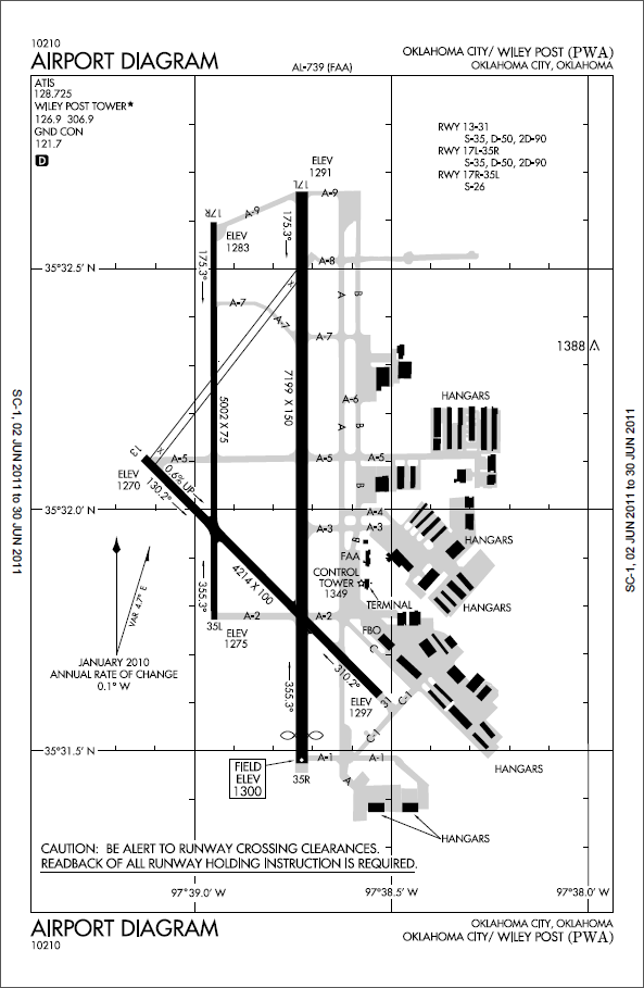
RUNWAY 17L/35R
Dimensions:7198 x 150 ft. / 2194 x 46 m
Surface: concrete, in good condition
Weight limitations:
Single wheel: 35000 lbs
Double wheel: 50000 lbs
Double tandem: 90000 lbs
Runway edge lights: high intensity
RUNWAY 17L
Latitude: 35-32.65997N
Longitude: 097-38.72980W
Elevation: 1290.1 ft.
Traffic pattern: right
Runway heading: 173 magnetic, 180 true
Displaced threshold: no
Declared distances: TORA-7198; TODA-7198; ASDA-6843; LDA-6843.
Markings: precision, in good condition
Visual slope indicator: 4-light PAPI on left (3.00 degrees glide path)
Approach lights: MALSR: 1,400 foot medium intensity approach lighting
system with runway alignment indicator lights
Touchdown point: yes, no lights
Instrument approach: ILS
Runway edge lights: high intensity
RUNWAY 35R
Latitude: 35-31.47357N
Longitude: 097-38.72945W
Elevation: 1299.3 ft.
Traffic pattern: left
Runway heading: 353 magnetic, 360 true
Displaced threshold: 355 ft.
Declared distances: TORA-7198; TODA-7198; ASDA-7198; LDA-6843.
Markings: precision, in good condition
Visual slope indicator: 4-light PAPI on left (3.00 degrees glide path)
Approach lights:
Touchdown point: yes, no lights
RUNWAY 13/31
Dimensions: 4213 x 100 ft. / 1284 x 30 m
Surface: concrete, in good condition
Weight limitations:
Single wheel: 35000 lbs
Double wheel: 50000 lbs
Double tandem: 90000 lbs
Runway edge lights: medium intensity
Operational restrictions: RY CLSD 2200-0700.
RUNWAY 13
Latitude: 35-32.10585N
Longitude: 097-39.13133W
Elevation: 1269.9 ft.
Traffic pattern: right
Runway heading: 128 magnetic, 135 true
Displaced threshold: no
Declared distances: TORA-4213; TODA-4213; ASDA-4213; LDA-4213.
Markings: nonprecision, in good condition
Touchdown point: yes, no lights
Obstructions: 25 ft. pole, 800 ft. from runway, 24:1 slope to clear
RUNWAY 31
Latitude: 35-31.61538N
Longitude: 097-38.53000W
Elevation: 1296.4 ft.
Traffic pattern: left
Runway heading: 308 magnetic, 315 true
Declared distances: TORA-4213; TODA-4213; ASDA-4213; LDA-4213.
Markings: nonprecision, in good condition
Touchdown point: yes, no lights
Obstructions: none
RUNWAY 17R/35L
Dimensions: 5000 x 75 ft. / 1524 x 23 m
Surface: asphalt/concrete, in good condition
SOUTH & NORTH 1000 FT CONC.
Weight limitations:
Single wheel: v26000 lbs
Runway edge lights: medium intensity
RUNWAY 17R
Latitude: 35-32.59750N
Longitude: 097-38.95167W
Elevation: 1282.0 ft.
Traffic pattern: right
Runway heading: 173 magnetic, 180 true
Declared distances: TORA-4001; TODA-4001; ASDA-4001; LDA-4001.
Markings: nonprecision, in good condition
Visual slope indicator: 4-light PAPI on left (3.00 degrees glide path)
Touchdown point: yes, no lights
RUNWAY 35L
Latitude: 35-31.77340N
Longitude: 097-38.95140W
Elevation: 1275.1 ft.
Traffic pattern: left
Runway heading: 353 magnetic, 360 true
Declared distances: TORA-4001; TODA-4001; ASDA-4001; LDA-4001.
Markings: nonprecision, in good condition
Visual slope indicator: y4-light PAPI on left (3.00 degrees glide path)
Touchdown point: yes, no lights
airport operational statistics
Aircraft based on the field: 387
Single engine airplanes: 310
Multi engine airplanes: 40
Jet airplanes: 35
Helicopters: 2
Aircraft operations:avg 229/day 66% transient general aviation
31% local general aviation
2% air taxi
1% military
additional remarks
- TOUCH & GO OR STOP & GO LNDGS NOT AUTHORIZED RY 13/31.
- FLOCKS OF BIRDS ON & INVOF ARPT ALL QUADRANTS.
- NOISE ABATEMENT PROC: ACFT IN EXCESS OF 12500 LBS DEPARTING RY 17L/35R CLIMB AT A MAX RATE CONSISTENT WITH SAFETY TO AN ALT OF 1500 FT AGL THEN REDUCE POWER SETTING & CLIMB RATE TO 3000 FT AGL OR 2 NM FM ARPT DEPENDING ON ATC & SAFETY CONDS.
- TWY A1 CLSD EAST OF TWY A INDEFLY.
- RY 13/31 CLSD TO JETS.
- RY 13 CLSD TO TKOF & RY 31 CLSD TO LNDG FOR ACFT OVER 12500 LBS GWT.
- TPA FOR RY 17R/35L 601 FT AGL; 1001 FT AGL ALL OTHER RYS.
- RYS 13/31 AND 17R/35L UNLGTD 2200-0700.
- TWY C-1 NORTH OF RY 31 THLD AND TWY C FM 100 FT EAST OF TWY A EASTBOUND DESIGNATED NON-MOVEMENT AREA.